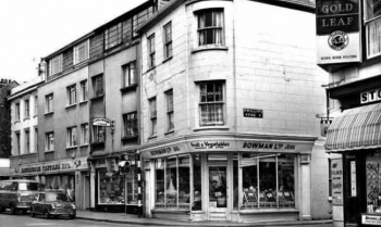
Bath Street as we know it today runs in a south to north direction from Queen Street to David Place. St Helier maps before 1800 reveal that the town was predominantly a linear arrangement of streets running from Colomberie in the east to Charing Cross in the west. The north of the town was mainly open countryside and orchards.
One of the few roads heading north and transecting the countryside is recorded on Meade’s plan of 1799 as ‘the road to Town Mills’. By the time of the 1834 Le Gros map, St Helier had undergone significant expansion, with many more roads and houses being laid out and constructed. On this map the road to Town Mills is now very clearly named Bath Street.
Public baths
It seems reasonable to suppose that it was named as such because there was a bathing establishment in the street. These public baths were constructed and owned by a consortium of prominent landowners and builders, among them William Le Breton, Nathaniel Westaway, Sir Colin Halkett, Clement Hemery, Philippe Le Gallais and George William Le Geyt.
They were in a building in Bath Street between Philip Street and Belmont Road. Census records show that the building was to the south of what is now Jeff Le marquand’s shop, and has long since been demolished, forming part of what is now the Royal Bank of Scotland International.
On the opposite side of the street to the baths, the General Post Office was in the building on the corner of Minden Place.
Numbering changes
Researching individual properties in Bath Street can be challenging, because between 1841 and 1927 the numbering system changed three times. According to the 1851 census, Bath Street was divided into Lower Bath Street, which was from Hilgrove Street to Beresford Street, and Bath Street, or Rue de la Commune, which extended as far as Gas Place.
By 1861, which may coincide with the development of the new postal system, the numbers had changed completely. At this time the street was still divided into Lower Bath Street and Bath Street, with Beresford Street and Peter Street being the boundary.
This division was more than just a name. Evidence from the census records of 1851 to 1901 listed residents of Bath Street as merchants, doctors, music teachers, piano tuners, chemists, ironmongers and perfumers.
This was in marked tcontrast to Lower Bath Street, which was much more of a working class area. The principal nationality of the residents was French, particularly from 1861 onwards. They are listed as agricultural labourers, dressmakers, rope makers, butchers, brush makers, publicans and laundresses.
In 1877 it was decided to extend Bath Street beyond Hilgrove Street in order to connect it to Queen Street, but a number of properties were in the way of the proposed enlargement. They belonged to Rachel Godfrey Rousseau and needed to be demolished to make way for the road. Mrs Rousseau made an offer to give up the properties to the parish in exchange for £250.
When the Parish Assembly discussed the offer they said that this area of town as it then existed was a perfect nuisance; on Sundays it being the resort of all of the vagabonds of the town. They proposed her most moderate offer be accepted, as it would be a removal of a nuisance; it was an eyesore noticed by strangers and a focus for the spread of epidemics.
Accordingly the road was extended and was known as New Bath Street. In the mid-1920s Bath Street was renumbered for the final time, incorporating New Bath Street, Lower Bath Street and Bath Street.
Music shop
By this time a number of businesses were well established in the street, including a high-class music shop run by brothers Cornelius and Alfred Donaldson. Founded by their father Cornelius in the late 19th century, it occupied an impressive building on the corner of Bath Street and Belmont Road, which is still there today.
It sold grand pianos, music and other instruments on the ground floor, and the upper floors were used as practice and teaching rooms from which people could hear the efforts of budding musicians as the passed by the building.
Making the corner of Bath Street and Charles Street is another distinctive building, which for 87 years was the headquarters of the Jersey Evening Post. The newspaper was founded by HP Butterowrth in 1890 and acquired soon after by Walter Guiton.
By the beginning of the 20th century plans had been drawn up by architect WP Proper to create a new building to acco0mmodate increasing numbers of staff and new equipment. The distinctive clock tower above the main entrace became the inspiration for the title of Meridian’s daily column, Under the Clock.
Cinemas
Apart from being the home of many and varied shops and businesses over the years, Bath Street has also been a popular area for entertaiment, with two cinemas being built there during the 20th cetury.
West’s Cinema, with its twin towers, dominated the corner of Bath Street and Peter Street for 50 years before it was demolished in the 1970s to make way for the square with various shops and restaurants.
At the other end of Bath Street is the Odeon, which was built in 1952. Designed by T P Bennett and Son of London, it is the only complete example of an Odeon cinema from this period. A better understanding of acoustics and the necessity for a more economic approach at that time led to its plainer design when compared to earlier cinemas such as West’s.
Despite closing as a cinema it has retained its status as a listed building and was purchased in 2012 by Freedom Church to be used by the church and the community.


