On the coast
|
 Greve de Lecq Harbour
 A new pier was built at Greve de Lecq in the 1870s as Jersey's northern bays became more popular with boat owners, but it was not to last very long
|
Pressure on the States to build safe harbours in Jersey's north coast bays started when Gorey Harbour became so busy, in the oyster fishing boom in the 1820s, that further anchorages were needed for the fleet.
An old jetty at Rozel was considered unsafe and the Constables of St Martin and Trinity, whose parishes meet in Rozel Bay, petitioned the States to provide a proper pier. Work was already under way at Bouley Bay and La Rocque to build piers in the two locations thought capable of providing the best facilities for the growing number of fishing vessels based around the coast.

Greve de Lecq, like Rozel, had had a jetty of some sort in earlier times, but it had either fallen into disrepair or disappeared completely. Its location is shown on a map produced by Charles and Collette Stevens in the 1980s to illustrate their work on Jersey place names.
The original idea for a new pier dates back as far as a 1713 survey carried out by Captains Edward Le Brun and J Mauger at the behest of Jean de Carteret, Seigneur of Vinchelez de Haut, and owner of the fief adjacent to where the pier was built. The view was that it was a most convenient place for a harbour to give shelter from the north wind for use by local people and other navigators. However, it was not until early 1864 that a States committee was formed (le Comité pour l’établissement d’un Havre à la Grève de Lecq) to take the matter forward.
Committee members
On 13 March 1864 a committee was formed comprising Jurats Edward Leonard Bisson, Jean Le Couteur and Jean Aubin, the Rector of St Mary, the Constables of St Lawrence, St Ouen and St Mary and the Deupties of St Peter, St Mary and St Ouen. By 2 August 1864 the committee had concluded that Greve de Lecq was well suited for the construction of a harbour and the site had been inspected by engineer Thomas Gallichan. The Seigneur and Tenants of the Fief of Lecq had agreed to give without charge a part of the Commune of Lecq and materials to facilitate the construction as the granite on site was 'in great abundance and of excellent quality'.
The 1870 Channel Island Pilot described Greve de Lecq bay as 'good and safe in all winds, excepting those from the northward'.
Work began on the pier in the spring of 1872 and the contract was valued at £8,000. On 7 May a seven-course dinner for members of the States committee and other influential islanders was served at the Greve de Lecq Hotel to celebrate the laying of the foundation stone.
The following year the States authorised a third loan to be taken out to raise enough money to complete the work. Philip Gosset, the manager of the Jersey Banking Company (and Treasurer of the States) bought £5,000 of the bonds using his own money taken from the Jersey Mercantile Bank. Two days after the money was safely transferred, the Mercantile Bank, whose manager, Mr Armstrong, was Gosset's brother-in-law, suspended operations.
In February 1872 States Engineer Imrie Bell had been appointed to inspect the site and the works already underway. The pier was constructed by contractor P L Amy and a Mr R Johnson was named clerk of works by the committee on 20 July 1872.
The sea wall and roadway from the pier leading to the main road was also constructed by Mr Amy in April 1873 and in March that year Imrie Bell met with Amy and Le Sueur to consider extending the pier head 150 feet to a total of 350 feet as 'experience has shown excellent granite on site'. This was quarried from the adjacent rock face and the cleared area became what is now the boat park. It was retained by the Seigneur, Thomas Le Cornu, and his successors until 2010 when the Dame, Carole Hart, transferred the land and large areas of headland between Greve de Lecq and Grosnez to the Public. In so doing, she transferred to the States her liability for the quarried rock face above the boat park, which was found on an earlier Visite Royale to be causing danger to boat and pier users below.

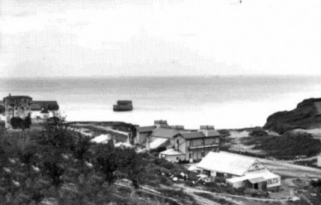
Schooner James Harmer
We have not discovered a date for the completion of the pier, but the magnificent photograph here, which occupied our Picture of the week slot in July 2017, shows the James Harmer to have been the first vessel to moor alongside in June 1876.
A 58-ton schooner, built in 1842, she was in French ownership at the time of her visit to Greve de Lecq. She had been bought by Philip Le Gresley, of St Martin, in 1874, and he sold her to French owners in April 1876, when she was taken off the Jersey register. He then bought her back in January 1877 and she was again entered on the Jersey register. He sold her again in April of that year to Clement Starck, who in turn sold her to Charles Dallain that August. In January the following year he sold her to Philip Gavey, who sold her to new French owners a month later.


Storm damage
Unfortunately the pier did not last very long. There is a certain amount of confusion over exactly when it was damaged, but a report produced for the States in 1885, by which time the whole centre section of the pier had been washed away, and the pierhead was in danger of suffering the same fate, provides a reliable chronology.
Part of the pierhead collapsed in a storm in late 1878. The Liverpool Mercury of 14 February 1879 recorded that engineers appointed by the States to look into the collapse reported earlier that month that the contractor was to blame for laying the foundations of the pier on sand and not sufficiently deep - and more importantly not in accordance with the specifications. It was later reported in English newspapers that the remedial work which the original contractor was ordered to undertake was to cost in the region of £2,000.
All appeared to be well until the winter of 1884. On the night of 20/21 December a storm described at the time as a 'hurricane' washed away a large section of the middle of the pier, which had already been weakened in an earlier storm

Inspection report
Report by civil engineer H G Hammond-Spencer
6 January 1885
- 'On 21 December the sea made a breach in the outer wall of the pier, which gave way under the violence of the north-westerly gales then prevailing, and more especially that of the hurricane in the early morning of Saturday 20th.
- 'You are aware that for at least 12 months past, considerable holes have existed in the lower party of this wall, and you have had partly carried out measures of protection for the same. It is quite certain that the immediate cause of the failure of the wall was that the waves by working through the holes in the face washed out the heart of the work and caused its collapse.
- 'Looking at the quality of the work in the wall now standing, no one can be surprised that such holes as were known to exist should have been formed by the action of the waves and tide.
- 'When the old pierhead at this place fell down in 1879 I was charged, in conjunction with Mr P S Le Cornu, to report to you on the whole question of the cause of that disaster, and of the manner in which the original works were executed.
- 'It is not necessary to be an engineer in order to see that the quality of the masonry is altogether wretched and worthless, and that if once holes were formed in the face (thus affording a hole for the sea) the collapse of the wall would only be a question of time, longer or shorter according to the severity of the gales.
Mr Hammond-Spencer also criticised the design of the pier, which caused the force of waves to be concentrated on the section which collapsed.
- 'A different outline of pier might have been given which would have diverted the waves instead of concentrating them. Under these circumstances it became all the more necessary that the character of the masonry should have been as nearly perfect as possible, instead of which it is most inferior.
The report recommended the rebuilding of the wall but went on to identify further problem.
- 'I consider the most important and difficult point to deal with is the lower portion of the masonry, at and about the level of low-water spring tides. This is the real weak point of the whole work, not only on account of the difficulties in working there but also of the exposure to which it is subjected.
He said that a close inspection at low tide revealed the state of the pier to be 'exceedingly bad, not to say alarming', with holes extending almost to the centre of the interior of the pier, allowing the sea to suck out the infill.
- 'I am convinced that it is a mere question of time for the destruction of the entire length of the old wall which remains, from the east end of the existing breach up to the head which was rebuilt in 1879.'
The writer estimated that the costs of repairs would amount to £3,500.
4 September 1885, a report by E C Breewday Thomas advised the States that for a second time there had been a breach of the breakwater due to gales and stated that the rubble could be useful in rebuilding.
More reports
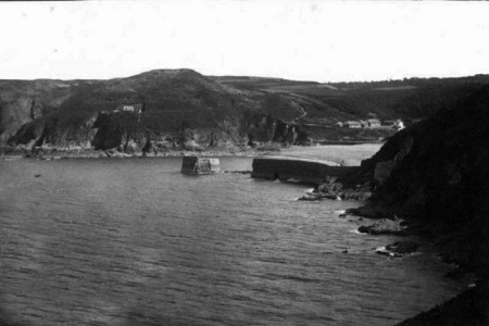
Hammond-Spencer's predictions proved correct. The pierhead eventually collapsed and the remains of the pier were strewn across the beach as a pile of granite stones of varying sizes. The loss of the isolated pierhead seems to have happened over a number of years rather than as a result of a single major storm. Although there are a number of photographs showing the pier in the aftermath of the 1884 storm, photographers taking subsequent images of the bay for postcards have tended to keep the damaged pier out of frame.
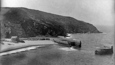
Pictures below taken in 1893 show that little had changed over 11 years, but by 1902 there was very little of the pierhead remaining, and it had disappeared by the first decade of the 20th century. At the other end the landward section of the pier was progressively washed away. The pictures below from about 1910 to the 1930s show the stub getting shorter, and the infill between what remained of the inner and outer walls all but disappeared.
But although the sea wrought its revenge by demolishing the pier, the granite rubble left behind has largely remained in place on the beach, following the line of the original structure.
In December 1936 a further report from the States Engineer, C W Rice, proposed another rebuilding scheme at an approximate cost of £3,500, although by July the following year this appeared to have been shelved.
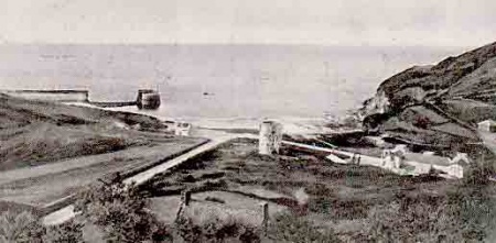
In the 1960s attention turned to repairing what remained of the shore end of the pier - two short sections of outer and inner wall with most of the infill missing - and reports by Coode and Partners in 1965 and 1969 recommended repairing the remains of the pier and providing a new slipway.
It would be another decade or so before this work was carried out by Regal Construction. The end of the remaining stub was rebuilt and widened, with concrete facing, and a new slipway constructed against the inside of the outer wall. The remains of the inner wall were demolished and stones cleared from the beach away from the original line of the pier.
The tea gardens of Café Casino and Colleens Café, which were on the sea side of the sea wall, got washed away. They were well used but probably should never have been there as they only had a base of rubble dumped over the sea wall.
Online errors
It is amusing to note that there are at least two active websites whose authors are sadly ignorant of the history of the pier and describe it as never having been completed, because funds ran out while it was being constructed. The reports claim that the rubble on the beach did not fall when the completed pier collapsed, but had been placed there awaiting further construction.
Gallery

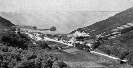
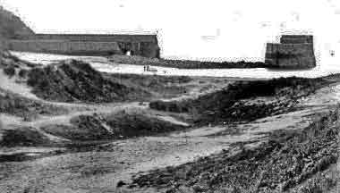
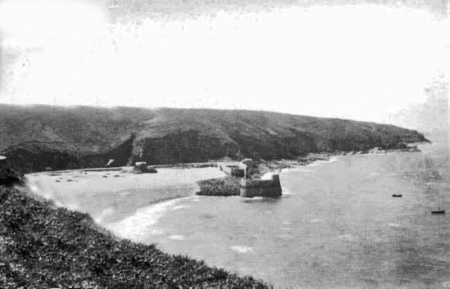
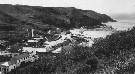
These photographs of Greve de Lecq, in as close to chronological order as we have been able to determine, show the pier in its original glory, and progressive demise, until what remained was finally repaired and secured. Click on any thumbnail image to see a full-size version.

1815

1870s

1870s picture by Ernest Baudoux

An albumen print showing the pier intact

The print digitally enhanced

The intact pier

Another picture by Baudoux showing the damage done to the pier in 1884

1885

1893

1893, From the Victoria and Albert Museum collection


1902

1905

c 1910

c 1915

1923

1930s

1948

1950

1951

1954

An early 20th century postcard

Repairs being carried out by Regal Construction in 1972

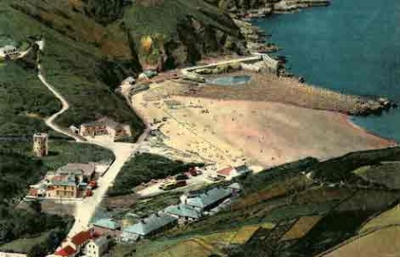
A recent satellite view shows the remains of the pier and the rubble which still covers the beach along the full length of the original structure

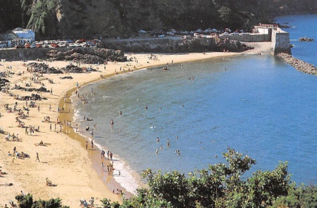
Greve de Lecq today. This Google Street View shows the remains of the pier on the right, with the line of rubble stretching along its original length

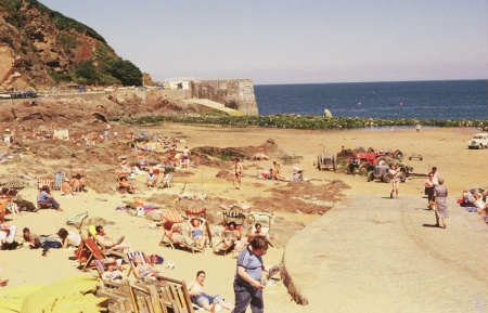
The remains of the pier today. What was left of the inner wall has been demolished and a slipway built up against the stub of the outer wall

A troop of soldiers on the beach after the second storm damage


