Beach Road

Beach Road

This article by Stuart Fell was published in the St Saviour Parish Magazine, La Cloche in 2020

St Saviour seaside
St Saviour may not immediately strike one as a seaside parish, yet its southernmost point terminates on the sea edge at Le Dicq slipway and the White Horse Pub, and nearby is one of the prettiest and best-preserved streets in the whole of the St Helier/St Saviour conurbation: Beach Road. It is a relatively recent creation, being developed in the last quarter of the 19th century.
It is of consistently high architectural quality and has always been a desirable place to live, with comfortable houses, a relatively peaceful neighborhood near to the beach, and within walking distance to town. From 1896 it even had its own railway Station. Dicq Road has earlier origins and provided a connection to the sea for the lands and property around.
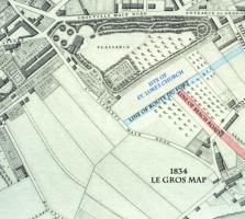
The Duke of Richmond map of 1787 shows just how built-up Dicq Road was at that time, with houses clustered around the junction with St Clement’s Road. Some of these properties survive, though much altered.
By 1849 St Luke’s Church had been built to serve a growing population to the east of the town and the first group of large terraced houses had been erected on the south side of Route du Fort, then known as Plaisance Road. Beach Road had been laid out but remained undeveloped. Dicq Road breaks Beach Road into two distinct parts, which are different in character.
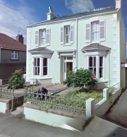
The first house to be built was probably Swissville (originally called East Lynne), which commands the northwestern corner of the Beach Road junction with Dicq Road. In a contract of 1882 Elizabeth Ann Burley bought the plot of land with the right to build on it, provided that the house faced Beach Road. The vendor was Jacques Godfray, who evidently owned much of the land in St Luke.
This building plot extended north as far as Dunell Road, but much of it remained undeveloped until the late 1960s, when a row of three, flat-roofed houses was built. Swissville is one of the few substantial detached houses in Beach Road, as most of the dwellings are built in terraces. In its architectural simplicity and stately appearance, it is almost rural in its character. But the canted bay windows, arch-headed window sashes, decorative hood over the door, and the decorative ridge cresting’s demonstrate its late 19th century origins.

Khartoum Villas and Gordon Place
Three terraces of speculative houses were soon to follow. The first of these was Khartoum Villas on the east side of the road. The northernmost house, St Luke’s Vicarage, was larger and more elaborate and faced the Church. These simple rendered facades with their canted bay windows provide the backdrop for a wealth of architectural detail that can be seen in in the cast-iron railings, decorative render trim around the windows and elaborate barge boards on the dormer windows.
Immediately to the south of Khartoum Villas is Gordon Place, made up of five houses, which extend southwards as far as Dicq Road. The names given to these terraces are a clear indication of their date, as General Charles Gordon, a man who captured the public imagination, was killed in the siege of Khartoum in 1885. A contract for the sale one of these plots dated 1883 required that the house was built within two years.
Gordon Place is different architecturally from Khartoum Villas as it introduces large overhanging gables and square bay windows. The composition of the façade illustrates the design skill of the builders, as there are three smaller houses and two larger ones, five in total, but there are only four gables. Here, apart from the first house, La Sirene, the frontage railings give way to rendered walls. On La Sirene, where the features are well preserved, there are French windows opening on to a balcony on the roof of the highly embellished bay window, which has a decorative ironwork balcony front. There is a canopy over the door, and decorative tiling on the entrance path. All of these decorative features are illustrated in builder’s catalogues of the time and could be bought ‘off the shelf’.
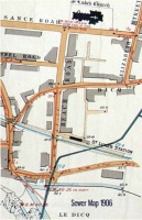
The third, un-named terrace, on the western side of the road, comprises six identical houses, with a seventh, larger plot facing Plaisance Road. Like much speculative development, such terraces were built in phases, according to the availability of funds. An extract from the sewers map by Francis Le Sueur, surveyed between 1906 and 1909, shows that the northern end of the terrace, and the end house, Mannamead, were yet to be built.
It also shows St. Luke’s Railway station at the southern end of Beach Road. In a postcard of St Luke’s district dating from around 1900, these residential terraces can be clearly seen, and it is apparent that the west side of Beach Road had not been completed at this time as the front of Khartoum Villas is visible. The un-named terrace has six similar houses, displaying distinctly Edwardian features, especially the linked roofs on pairs of houses over the bay windows and front doors, which are covered in red clay tile and supported on decorative timberwork. The two-tone brick chimneys, in red and yellow, were also common in this period, as were the small half-timbered gables over the paired windows, and the butterfly style front railings. Decorative leaded-light windows over the doors and in the upper lights of the bay windows complete the picture. But perhaps the most unusual feature is the eccentric shape of the cement surrounds to the windows, which add the visual richness of these stylish Edwardian house fronts.

Coast end
The section of Beach Road extending down to the coast road has so many interesting properties. For decades, one of the distinguishing features of this part of the road was the crossing of the Jersey Eastern Railway. This came into service on 7 August 1873, following the success of the Western Railway.
The Eastern Railway provided a connection between St Helier and Gorey, and served the expanding suburbs of St Helier, St Luke and Georgetown. St Luke’s Station, which stood on the north-eastern side of the crossing with Beach Road, was not opened until June 1896, following the closure of the Georgetown station. The railway was profitable until the 1920s but increasing competition from bus services led to its closure in 1929. The land and buildings were quickly sold, and redeveloped, and little trace of its existence now remains.
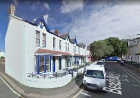
In an aerial view taken in the late 1950s, the line of the former railway can clearly be seen in the long ribbon of buildings that cross Beach Road only a short distance from the coast road. In the area where the station and its platform stood, a row of nineteen modest and closely spaced houses was inserted, each with a small south-facing garden. This is Beach Crescent, which starts in St Saviour and ends in St Clement, and is probably one of the narrowest rows of semi-detached houses in the Island.
Despite its name, the curve in the line of houses is barely perceptible. In 1871 the Jersey Eastern Railway Company prepared a detailed plan showing the full extent of the proposed line and the properties that would need to be purchased. There was opposition from some quarters, but the majority of owners were prepared to give up their land provided that they were compensated fairly.

All the land to the south of Dicq Road on both sides of Beach Road was held by a single person, George Snell, who was a very active landowner and property developer. Two blocks of semi-detached houses had already been built on the west side of the road. The first pair, named Havelock and Morcott, lie just to the south of Dicq Road and are very cottagey in character, due, perhaps to the low-slung proportions and roughcast render finish. Architecturally, they are quite unlike any other houses in the area and may well be the oldest in Beach Road.
Further to the south lies a larger pair of houses, Casa Marina and Marina House, which stood in generous gardens. Behind these houses to the west is an area of open land that was later to accommodate the Hotel de Normandie. Casa Marina and Marina House were occupied as dwelling houses for at least 50 years, but by 1932 they had been combined and converted into Hotel Casa Marina, no doubt to capitalise on the rapidly expanding tourism presence in Havre des Pas and Le Dicq. In the 1931 edition of The Official Guide to Jersey, a full-page advertisement shows the ‘new and up-to-date’ premises in their pristine state, the proprietor being Mrs E B Averty. The hotel was still in the hands of the Averty family in the 1980s, but in more recent times it was incorporated into the Hotel de Normandie when it was substantially rebuilt and enlarged, sadly resulting in the loss of its character.
Residential blocks
On the east side of the road two residential blocks were constructed. The first, St Luke’s Villas, consists of five houses, four of which have intriguing names – Palmyra, Mosul, Bitterne, and The Cheal. While possible derivations for the first three names can be found, a plausible meaning of The Cheal has so far proved elusive. Architecturally, these are dignified houses forming a pleasing composition, tied together visually with a strong cornice at roof level. The semi-circular headed windows over the front doors provide variety and the decorative ironwork is of high quality, as elsewhere in the street.
Dating old houses can be difficult, and it is fortunate that St Luke’s Villas were built by Charles John Le Quesne, founder of the quarrying and building dynasty, as useful family records have survived. In his memoire, C T Le Quesne, Charles John’s grandson, explains: “When he Charles John was about 25 he built a row of houses in Beach Road, of which one was for my mother’s father, Capt Philip de Faye, and now belongs to her, and another was for himself. Others were for a Mr Le Geyt and a M Snell.”
The house retained by Charles John, The Cheal, became the home of his daughter, Dorothy, who was sickly; it was thought that she would benefit from living close to the sea rather than in the town. After Charles John died, in 1925, his widow and his eldest daughter, Winifred, went to live there.
Directly across the road lie Royal Villas, a pair of houses almost identical in appearance to St Luke’s Villas apart from some minor differences in decorative trimmings. The last significant group to consider is Lucknow Place, a terrace of five houses that lies between St Luke’s Villas and Dicq Road. This is a tour de force of Edwardian residential building, with its rather bizarre render decoration and good ironwork, nicely picked out in thoughtful colour schemes. Baxby, on the junction with Dicq Road, is the largest house and steps its way around the corner with considerable finesse.
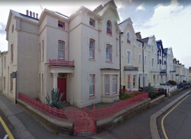
Despite the high density of building in this area, a few gaps remained in Beach Road until the 20th century, but these eventually succumbed to development. The most prominent of these, Victoria, stands at the junction of Beach Road and Dicq Road. It is a very distinctive and popular style of dwelling, with its projecting gable, tiled roof and mock Tudor timber-framing, and houses like this are ubiquitous in suburban areas throughout the British Isles. It is rare to find streets with such a wealth of architectural and historical interest and Beach Road is undoubtedly one of Jersey’s treasures.
-
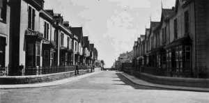 1940s
1940s -
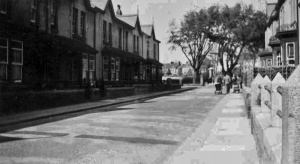 1940s
1940s -
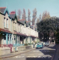 1980
1980 -
-
-
-
-