St Ouen C tower
From Jerripedia
Jump to navigationJump to search

St Ouen C Tower
There is no surviving picture of this tower, which is thought to have been constructed before 1795 and to have disappeared some time between 1849, when it was shown on Hugh Godfray's map of the island, and 1933, when there is no sign of it on the Ordnance Survey map. It is believed that it was undermined by the sea, which encroached closer and closer across the sandy shore to where it had been built
-
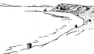 A sketch made by J Le Couteur in about 1840 which shows the five towers at the northern end of St Ouen's Bay, C and D towers in the foreground, followed by Kempt and Lewis towers, with L'Etacq Tower at the far end of the bay. Only Kempt and Lewis Towers remain

